gringo:
Used as a disparaging term for a foreigner in Latin America, especially an American or English person.
Food, fuel and checkpoints
All of the fuel coming out of the pumps was good. Although in most instances high-octane fuel was not available for my high-performance heads, I never noticed any degradation in engine performance. I had absolutely no trouble with fuel.
The food was excellent. Roadside taquerias presented some of the best fish tacos I’ve ever eaten. The restaurants, both local and of ethnic variety, were fabulous.
Checkpoints were many, with the usual troops with machine guns. In at least one instance, it was a little unnerving to see a plain-clothes officer sporting an M-16, but I quickly got over it. Never once did I have a problem at a checkpoint.
Tolls were a major distraction for the entire mainland ride north from Los Mochis. The average fee was 50 pesos. As a result, the road was very good.

Preliminary Chores
I had wanted to ride down the Baja for years, but normal, everyday pressures of job and responsibility prevented me from doing so – until now. Finally I had the time, since I had quit my job a year previously for greener pastures, so to speak, and here I was in southern California, in March, 2001. At this time of year the weather is perfect for a sojourn down the Baja.
Various permits are needed to cross into Mexico with a vehicle and travel beyond the Baja border zone, so time was spent obtaining the appropriate paperwork in Mexicali prior to departure. This “Border Zone” extends north from San Quintin on the Baja, but only includes an area 25 kilometers (15 miles) south of the border on the mainland. Since I would be crossing onto the mainland by ferry from La Paz, I would need all of the paperwork. For more details, check out the two links below:
Visa / Tourist Card requirements for foreign travelers in Mexico
Vehicle insurance is also a requirement. You MUST buy liability insurance to ensure that you don’t end up spending time in a Mexican jail if you hit someone or something with your vehicle while in Mexico.
As of 2006, motorcycle theft insurance is available. Shop around for the best rates.
The links above can be found at the following site:
Mexican Insurance Services, Inc.
For those of you with membership in AAA or the CAA, you can purchase liability insurance for coverage while in Mexico at any office of the Automobile Club of Southern California.
With all paperwork in hand, and duly rested, fed and fueled, I headed south on the 10 and subsequently the 86 to Calexico on a Friday morning. The old border crossing into Mexicali was closed due to a taxi driver protest and strike, but fortunately there is another entrance to the east. It’s a brand new crossing, and normally it isn’t busy. I sailed across, and was on my way.
Topes, or Speed Bumps
Prevalent throughout Mexico, the topes mark the perimiter of most of the towns and cities on both the Baja and the mainland. If one is not careful, they’ll launch you into the air when crossed at speed. Most are marked, some are not, and it pays to keep an eye out for an unexpected surprise.
A thousand miles to go
I headed south on Mexico 5 to San Felipe on the Sea of Cortez for a little R and R before beginning my quest. This highway is mostly divided four-lane well past the outskirts of Mexicali, and then turns into a somewhat narrow, two-lane blacktop that is surprisingly well-maintained.
For the most part, Mexico 5 runs straight and true all the way to San Felipe. It’s narrow, but the pavement is good, and although there are some arroyos or dips to watch out for, one can make speed, even though the legal limit is 80 kilometers an hour.
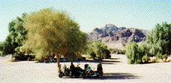
Fortunately, the run through the Laguna Salada was without incident. I’ve ridden through this area in the past, and if there’s a wind blowing at strength, dust and sand can make the passage miserable. At kilometer 105, I eased onto the gravel parking lot of La Ventana, a one-pump bump in the highway for gas and refreshments. I parked under the only tree for a bit of shade and wandered over to the cantina.
Thirty minutes later, I was back on the road and crossing the Llano El Chinero, or Chinese Plain. A large group of Chinese immigrants trying to reach Mexicali on foot early in the 1900s died here, thirsty and starving. I passed by the nearby junction of Mexico 5 with Mexico 3, which would later take me west and then north to Ensenada. There’s a huge, pink abandoned building at the crossroads. By the look of it someone once had a go at a restaurant/gas station, and failed.
There are at least two military checkpoints on Mexico 5 to pass through on the way to San Felipe. Normally this is an uneventful experience, although to the uninitiated it may be frightening. The very young-looking regulars are normally commanded by an older officer. Rarely is English spoken. Automatic weapons are ready for use and there will be at least one, and most times, two, machine gun nests. For the most part these young troops want to look at the motorcycles, and I slowed down and was waved though both checkpoints without having to stop.
Once past the Mexico 3 junction and closer to San Felipe the east side of the highway is rife with signs for beach camps all the way into town. I’m not going to dwell on the place here, for there are plenty of San Felipe web sites to do it for me. One thing I will mention, however, is the excellent fare to be found on the malecon, especially the fish tacos. Superb! Furthermore, the Rockodile, the Barefoot Bar, the Bearded Clam and the Beachcomber, among others, all have their own “special” atmosphere, from hanging upside-down to dancing and drinking all night long.
Cautionary Note
All the highways I traveled on were in good repair, although somewhat narrow, and speeds well in excess of the posted limit of 80 kilometers (50 miles) per hour can be maintained for mile after mile. In many instances, livestock roamed freely, or was tethered at the side of the road. Almost daily, dead carcasses were passed, probably due to someone making a “connection” at night. I do not recommend riding the Baja at night, and in fact I was off the road well before dark most of the time.
On the road
After a couple of days of sampling the delicacies to be had in San Felipe, it was time to backtrack 30 miles on Mexico 5 and pick up Mexico 3 to head west across the peninsula to Ensenada and the Pacific. The day turned cool and cloudy roughly 20 miles into highway 3, and around Valle de Trinidad and the Restaurant Vista Bella it was time to put on the rain gear for the cold drizzle that was plainly ahead.
On the south side of the highway at Ojos Negros, fuel is available for the 152 mile ride to Ensenada. I’ve stopped here before, always surprised by the oasis of green surrounding the area. This lies in sharp contrast to the approach to Ensenada 23 miles farther west, and as one gets closer, the garbage-strewn fields and yards on the outskirts become more obtrusive and are an eye-sore to my sensibilities. Each time I ride by I wonder why no one cares enough to clean it up – certain to be a full-time job for many.
Baja’s third-largest city was not for me this time, although in earlier years I’ve spent some time in Hussong’s Cantina. A stop for fuel and I was on my way south on Mexico 1. Heavy traffic didn’t thin out until well south in this heavy agricultural area. It was still cool running, so at Santo Tomas, producer of the well-known wine of the same name, I stopped for soup and bread to warm up.
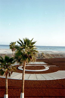
The approach to the hotel in San Quintin was through a canopy of trees overhanging both sides of the roadway to the ocean. It had remained cool and cloudy for most of the day, and I was grateful to be off the road and in a warm hotel with good food and drink.
Temperatures the next morning remained cool, but Cataviña and lunch beckoned at the Desert Inn, although it appeared to be relatively empty upon arrival. My overnight stays might appear to be a commercial for the Desert Inns chain (formerly the La Pinta chain), but I highly recommend them for their consistently clean rooms, good food and marvelous architecture. Besides that, I’ve spent a lifetime in tents and dives around the world, and have had enough of them.
At Punta Prieta, the Vizcaino Desert commences its 130-mile journey south. Normally this would be a very arid region, but due to the abnormal wet weather for the time of year, a somewhat lush plain of green beckoned. Be warned though, that when the wind blows, this is a miserable place to be caught, green or brown.

North of Guerrero Negro I was stopped at the border to Baja Sur. This doubles as an agricultural inspection station as well, and automobile undercarriages were being sprayed with something, although I’m not sure what. I managed to get by without going through this ordeal, but I did have to show my papers.
Paralelo 28, as it is known, is the location of a huge 140 foot high stylized eagle commemorating the completion of Highway 1 to unite Baja California Norte and Baja California Sur.
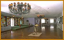
And once again, I’m at the La Pinta. Take a look at the lobby of this fabulous place. And don’t forget to reconnoiter Scammon’s Lagoon, renowned for its whale-watching.
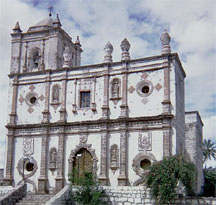
South of Guerrero Negro lies the beautiful oasis of San Ignacio, surrounded by a forest of palms and ponds. I parked in the town square under a huge overhanging tree, across from the 18th-century mission and took a well-deserved break from the wearying road.
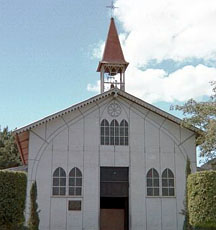
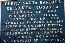
At Santa Rosalia I once again ran up against the Gulf of California on the west side of the peninsula. The Santa Barbara church is of pre-fab metal designed by G. Eiffel of Eiffel Tower fame. This church was originally set up at the Paris World Fair in 1889, and sent to Baja in pieces 100 years ago.
This leg of the trip along the coast through Mulege was perhaps the most scenic so far, with sweeping ocean vistas interspersed with white sand beaches all the way to the Bahia Concepcion. At Loreto I stayed at the local La Pinta, a gorgeous hotel on the waterfront and faced the next morning’s sunrise.
La Paz is a beautiful city, and the Club El Moro proved to be a grand place to stay. Whales frolicked in front of the cafe, and a stroll along the malecon provided further whale-watching entertainment. I picked up some souvenirs for friends back home, and rested my weary bones for the next two days seeing the city sights, eating in the cafes and various ethnic restaurants, and generally relaxing. I could spend time here.
I was at the 1,300 mile mark since leaving home, and I still had to cross by ferry to the mainland and head north to Nogales. The ferry offices are located to the northeast of the city in Pichilingue. I made my arrangements – 550 pesos for the bike and 690 for the cabina – and returned to the El Moro for a last lunch before the mainland. My instructions were to arrive at the port at 6 p.m. to be loaded. Of course, the wait was much longer, and I boarded the ferry at 10 p.m. after watching every other vehicle being backed onto the ship.
The good part of all that is that I would be first off on arrival in Topolobampo near Los Mochis, an advertised 8 hour excursion that actually took the better part of 12 hours to travel the 150 miles across the Gulf of California.
My motel in mainland Guaymas on Mexico Highway 15 proved to be of the “short-stay” variety. Although the rooms in the Hotel Flamingos were new and well-kept and separate from the older building, there appeared to be several rooms in the main part that were rented by the hour. This became fairly obvious the next morning at breakfast, when a very attractive but obviously “tired” young woman came into the restaurant. I watched her devour a cup of coffee with trembling hands, and I remembered well several of my previous lives when, first thing in the morning, I was in a similar condition.
A straight shot to the border on the four-lane Highway 15 and I’m in familiar territory now, but it’s still a shock to the system to see the extraordinary measures used to keep people out of the country at the Nogales crossing. I won’t go into details, but suffice it to say that seeing it on television doesn’t do justice to the reality of it. The Border Patrol agents have their work cut out for them, and I don’t envy any of them their jobs.
Would I make the trip again?
You bet I would, in a minute. While I certainly didn’t cut any costs, one can spend a lot less money by staying in cheaper accommodations.
The people were hospitable, the food was good and the country was fantastic. My only disappointment was in not being more familiar with Spanish, but that was the fault of no one but me.
I would change one thing, however, and that is that I wouldn’t bother crossing over to the mainland. For me that time was wasted, when it could have been spent in La Paz, or in backtracking north over familiar territory and seeing more of the sights.
For those of you contemplating making your own trip down the Baja, planning is important. Do your research, decide on how many miles you want to ride in a day, where you might like to stay and where you might get fuel. Although many of the guide books made reference to fuel availability at specific locations, it was my experience that this was not always so. NEVER pass up an opportunity for fuel.
